| | Hafan Home | | | | Chwilio Search | | | | Hanes a dogfennau History & records | | | | Degwm Mynegai Tithe Records | | | | Mapiau'r Degwm Tithe maps |
|
Mapiau'r Degwm |
Tithe maps |
|||
|
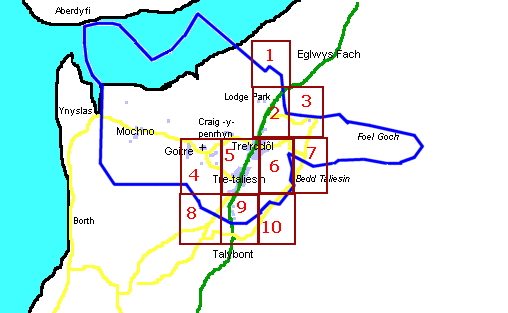
Tynnwyd map y Degwm yn 1844 fel rhan o'r waith o newid taliadau'r degwm mewn cynnyrch i daliadau mewn arian parod. Arolygwyd yr holl blwyf a thynnwyd map ar raddfa o 12 modfedd i'r filltir. Rhoddwyd rhif i bob eiddo er mwyn croesgyfeirio i'r rhestr dosraniad. Rydym wedi scanio rhan o'r map mewn nifer o rannau. Er mwyn gweld map naill ai ei dewis oddi ar y rhestr isod, neu cliciwch ar ran priodol y map. |
The Tithe map was drawn up in 1844 as part of the work in converting the Tithes in kind to a cash payment. The whole parish was surveyed and a map was drawn at a scale of approx 12 inches to the mile. Each property was numbered so that it could be cross-indexed with the apportionment list. We have scanned part of the map in a number of sections. To view a map either select it by number from the list below, or click on the appropriate part of the map. |
 |
| Cwestiynau? Sylwadau? Beth ydych chi'n meddwl am y tudalen hwn a gweddill y wefan? Dywedwch yn y llyfr ymwelwyr. Questions? Comments? What do you think about this page and the rest of the site? Tell us in the guest book. |