| | Hafan Home | | | | Chwilio Search | | | | Hanes a dogfennau History & records |
|
Mapiau |
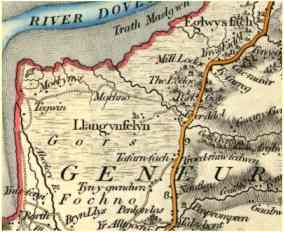 G & J Cary, 1829 |
Maps |
Ar y tudalen hwn... |
On this page... |
|||
|
|
Mapiau Llangynfelyn |
Maps of Llangynfelyn |
|||
Tynnwyd nifer o fapiau yr ardal dros y canrifoedd: yn anffodus mae Sir prinder manylion ar y rhan fwyaf ohonynt. Mae mapiau Cymru a Aberteifi ar gael o'r unfed ganrif ar ddeg ymlaen sy'n cynnwys enwau sawl llefydd yn y plwyf. Mae mapiau Ystâd Lodge Park ar gael yn y Llyfrgell Genedlaethol o tua 1785, sy'n cynnwys manylion sawl rhan o'r plwyf. Map cynnar arall yw y "New Map of Cardiganshire" gan Joseph Singer, 1803, ar raddfa o un fodfedd i'r filltir. Wedyn, map manwl cyntaf y plwyf oll sydd gennym yw Map y Degwm, sef map wedi'i dynnu yn y 1840au i gofnodi perchnogaeth y tir a gwerth y Degwm: eto, mae copi ar gael yn y Llyfrgell Genedlaethol. Ar yr un pryd, dechreuodd gwaith yr Arolwg Ordnans syn gyfrifol am fwyafrif y mapiau erbyn hynny. |
A number of maps of the area have been drawn over the years: unfortunately there is a lack of detail on the majority of them. Maps of Wales and Cardiganshire are available from the sixteenth century onwards that mention the names of a number of places in the parish. Maps of the Lodge Park Estate are available in the National Library, dating from about 1785, which contain details of several parts of the parish. Another early map is Joseph Singer's "New Map of Cardiganshire" of 1803, at a scale of 1 inch to the mile. Later, the first detailed map of the whole parish that we have is the Tithe map, which was drawn up in the 1840s to record ownership of land and value of the Tithe. Again, a copy is in the National Library. At about the same period the Ordnance Survey started work, which is responsible for the majority of maps since then. |
|||
Yr Arolwg Ordnans |
The Ordnance Survey |
|||
Yr Arolwg Ordnans yw'r sefydliad syn gyfrifol am y mwyafrif o fapiau Brydain: er bod llawer o gwmnïau yn cyhoeddi mapiau, data wedi'i casglu gan yr Ordnans yw'r sail. Mae'r Ordnans yn gadw hawlfraint ar eu mapiau am hanner ganrif ar ôl yr arolwg sydd ar sail y map. Felly, nid oes mapiau manwl ar y safle hwn syn ddyddiedig ar ôl 1949. Mae pawb yn gyfarwydd â'r mapiau 'un-fodfedd' (graddfa 1:50,000 heddiw): cyhoeddwyd map Ordnans cyntaf 'un-fodfedd' yr ardal yn 1837-40. Erbyn hyn, mae'r Ordnans wedi mapio'r holl wlad ar raddfa o 1:2500, sef tua 25 modfedd ir filltir. Cyhoeddwyd map cyntaf Llangynfelyn ar y raddfa hon yn 1881. Mae pob dalen y map 1:2500 yn enfawr - rhyw 36 x 24 modfedd, sef tua 1.5 milltir sgwâr. Felly, mae'n anodd iawn eu rhoi nhw ar gyfrifiadur. OND - rydym wedi ei gwneud! Roedd angen sganio'r mapiau ar 72 pixel/modfedd, mewn rhannau tua 8 x 10 modfedd: mae pob dalen mewn 18 rhan. Rhannau'r plwyf sydd â phobl yn byw yno yn unig sydd wedi'i sganio ar hyn o bryd. Mae cyfres arall o fapiau ar raddfa 6 modfedd i un filltir, seiliedig ar y gyfres 25 modfedd, a chyfres 2.5 modfedd i'r filltir (cyhoeddwyd yn 1948) ar gael hefyd. Wrth gwrs, doedd y Byddin ddim yr unig bobl a aeth allan i dirfesuro. Roedd y Llynges yn dra brysur hefyd... |
The Ordnance Survey is the body which is responsible for the majority of British maps: although many companies publish maps, the basis is usually data collected by the O.S. The Ordnance keep copyright on their maps for 50 years after the survey which is the basis of the map. As a result, there are no detailed maps on this site which date from after 1949. Everyone is familiar with the O.S. 'one-inch' maps (now 1:50,000 scale). The first O.S. 'one-inch' map of the area was published in 1837-1840. Since then, the O.S. have mapped the whole country at a scale of 1:2500, about 25 inches to the mile. The first map of Llangynfelyn at this scale was published in 1881. Each sheet of the 1:2500 maps is enormous - 36 x 24 inches, so about 1.5 square miles. As a result it's very difficult to put them on a computer. BUT - we have done it! It was necessary to scan them at 72 pixels/inch, in parts about 8 x 10 inches. Each sheet is in 18 parts. Only those parts of the maps showed the populated area have been scanned. Another series of maps at a scale of six inches to the mile, based on the 25in maps is also available, as is a series of maps at 2.5 inches to the mile (published 1948). Of course, the Army weren't the only people who went out surveying. The Navy were quite busy too... |
|||
Geiriadur daearyddol |
Gazetteer |
|||
Rydym wedi paratoi geiriadur daearyddol ('gazetteer'), sef rhestr o bob lle wedi'i enwi ar y map 6-modfedd - a nifer o lefydd eraill heb eu henwi. Hefyd, mae'r rhestr yn rhoi croesgyfeiriad i'r ffyrdd gwahanol o sillafu sawl o'r enwau. Wedyn, y mae'n bosibl ichi fynd yn syth o'r rhestr i ddarn priodol y map. |
We have prepared a gazetteer that lists all places named on the 6-inch map, and a number of other places which aren't named. This also gives a cross-reference of the different ways of spelling some of the names. It is then possible to go straight from the list to the appropriate part of the map. |
|||
Mapiau ar y safle |
Maps on the site |
|||
|
|
|||
| Cwestiynau? Sylwadau? Beth ydych chi'n meddwl am y tudalen hwn a gweddill y wefan? Dywedwch yn y llyfr ymwelwyr. Questions? Comments? What do you think about this page and the rest of the site? Tell us in the guest book. |